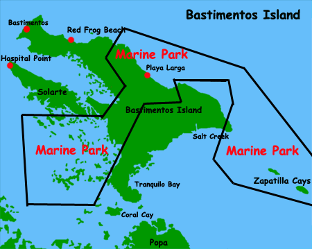

The Bastimentos Island National Marine Park, is located on the Bocas del Toro archipelago. It occupies 13,226 hectares of land and sea. Zapatillas Cays attracts most of the tourists who arrive to the region, but the Park has many other attractions. Isla Bastimentos national marine park was set up in 1988.
You can see from the map that the Marine Park consists of the central part of Bastimentos Island, both Zapatillas Cays and the waters surrounding them, plus the mangroves zone at the south of Bastimentos island. Whilst the total park area is 13.226 hectares, 11.596 hectares are part of a marine area.
On the south coast of the island, there is quiet Almirante lagoon with many channels winding through the mangrove islets, surrounded by corals and sandy shallows covered in meadows of sea grass (Thalassia testudinum). The park has the largest area of Caribbean mangrove swamp in the country as well as the best conserved coral reefs on that coast, where you will find both red mangrove (Rhizophora mangle) and white mangrove (laguncularia racemosa). The mangrove islets on the south of the Park, is a great place to cruise boat, or to snorkel among the mangrove roots.
Playa Larga on the north of this island is a long, sandy, beautiful beach. There is where marine turtles come to nest during the months of April to October. Access ito Playa Larga is not easy. The heavy surf makes a sea approach difficult, and thick forest runs right up the very edge of the beach, making hiking there difficult.
The Zapatillas Cays are a big tourist attraction You can snorkel, dive or swim in the clear waters, lie back on the sandy beaches or explore the small interior forest using the trail provided by the park rangers.